• Home
  • Take-off
  • Checklist
  • PDF-presenter
  • ColourVote
  • Contact
available at iOS App-Store

Take-off

Picture
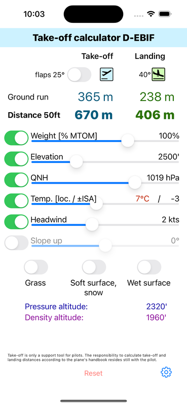
The take-off calculator gives you an instant overview if a certain runway is long enough under the current conditions. You can adjust external parameters like elevation, QNH, temperature, wind, slope and weight conditions. Pressure altitude and density altitude are calculated and displayed.
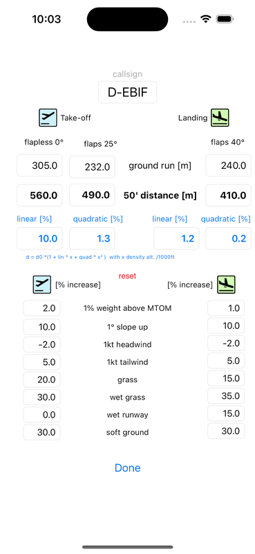
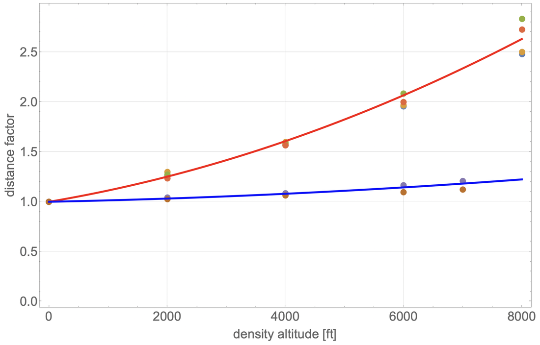
The current version uses the density altitude to determine ground run and take-off / landing distances with a quadratic approximation. All other influences are estimated using rule-of-thumb estimators. Customize all internal calculation parameters to your own aircraft in the settings menu to reflect your own situation.

Picture
Determine:
  • take-off ground run: distance the aircraft is rolling on the runway
  • take-off distance 50ft: distance the aircraft needs to clear an obstacle of 50ft  height.
  • take-off distances can be calculated for two flap settings, labelled 0° and 25° here.
  • landing ground run: distance the aircraft is rolling on the runway from touchdown point to the stopping point.
  • landing distance 50ft: distance that is required to bring the aircraft to a stop after clearing a 50 ft high obstacle.

Parameters:
  • Runway elevation in feet
  • QNH in hecto Pascal
  • Temperature in °C or +/- ISA
From these three parameters the density (and pressure) altitude is calculated which majorly influences the distances.
  • Weight deviations from MTOM in percent. Keep  in mind that exceeding MTOM is illegal.
  • Headwind / tailwind in knots
  • Sloping runway in degrees
  • Surface conditions (grass, wet grass, wet tarmac, soft ground)

Reset restores the starting values (QNH=1013, alt=0', temp=ISA)

Picture
On the settings page all parameters of the underlying model can be changed and customised. Changed values persist on each device.
  • Ground run in meters. This is the basic distance (alt=0', QNH=1013, temp=ISA, no wind, MTOM) the aircraft rolls on the runway in one of the three settings (take-off flapless, take-off 25° flaps and landing full flaps)
  • 50 feet distance in meters. This is the basic distance (standard conditions as above) the aircraft needs to clear a 50 feet high obstacle in one of the three settings (take-off flapless, take-off 25° flaps and landing full flaps)
  • these basic distances are altered with the density altitude using a quadratic model:  d = d0 * (1 + lin * x + quad *x² ) where x is the density altitude measured in 1000 ft (so for 4000 ft: x=4), lin. is the linear factor in percent (so for a 5% increase every 1000 ft, enter 5), quad is the quadratic factor (standard is 1.3%, meaning that at 4000' (x=4) we calculate  4*4*0.013=0.208. So the quadratic term alone leads to a 21% increase in distance plus the contribution of the linear term.
    •   ​if you want just a linear model, like the rule of thumb (10% for each 1000 ft) then set the quadratic term to 0 and enter 10 for the linear term.
    • if you have more precise performance data for your aircraft from your handbook, you can find a quadratic fit (with Excel or any other program) and enter the values you obtain here.
  • All the following corrections factors like MTOM, slope, wind and surface conditions are given in percent per unit of change.
    • e.g. 1° of slope up equals a 10% increase in distance here. So 4° of slope would be 40% increase. You can change these values but make sure they stay within a meaningful range. 
  • ​All values represent "rule-of-thumb" estimates. Often there's quite a wide range of possible values like for "soft ground". It is up to you to use these correction factors responsibly. Ultimately you should only rely on information from the aircraft's handbook. This app can only give a quick but rough estimate in complex situations.
Picture
  • The default settings for linear and quadratic factor reflect the values given in the handbook of a Piper PA28-R200.
  • The dots represent the handbook values for ground roll and take-off / landing distances versus the density altitude.
  • The RED line is the quadratic fit for take-off roll and distance. 
  • The BLUE line is the quadratic fit for landing roll and distance.
  • The error of the fit is only a few percent which is good enough to get an idea for the required take-off / landing distances. These distances are always just an estimate since personal skill level and changing wind / weather conditions introduce a much larger uncertainty.
  • Distances should always be required to be significantly shorter than the actual runway length.
Get Started

Privacy policy

The app take-off does not collect or ask for any personal data. All data is only relevant for handling a certain type of aircraft and is stored locally on your device.
HOME
PORTFOLIO
ABOUT
CONTACT
Powered by Create your own unique website with customizable templates.
  • Home
  • Take-off
  • Checklist
  • PDF-presenter
  • ColourVote
  • Contact